Tag Archives: adventure

Tokyo – 5 Wards in 5 Days!

Tokyo is a multi-faceted gem. Avant-garde technology resides right next to minka – traditional wooden houses with tatami mat flooring and sliding doors, modern skyscrapers butt heads with world heritage shrines and temples, smart businesswomen wearing six-inch stilettos and Gucci handbags come face to face with highly trained professional geishas in colourful kimonos and wooden clogs, while international food-chains like McDonalds and Starbucks compete with historic dishes such as sukiyaki, ramen and miso soup.

How to imbibe all these contrasting, yet strangely harmonious cultural traits while getting the most out of one’s vacation? Having spent almost fifteen hours in the air on two interconnecting flights to arrive at my destination, I couldn’t wait to see and experience as much as possible. Five days dedicated to one city seemed like a lot while I was planning my trip, especially since there was so much else to see outside of Tokyo, however once I was there, I realised that cramming everything into five days was actually going to be quite a feat.

The metropolis of Tokyo, formerly known as ‘Edo’, has a nucleus which is made up of 23 ‘wards’ or municipalities. Each of these is worth exploring and offers a multitude of attractions, yet of course, there are wards which are more popular than others. If you have limited time at your disposal, a good way of delving into Tokyo would be to dedicate one day to each particular municipality. While I was researching and planning my visit to the capital of Japan, there were five particular ‘wards’ which piqued my interest most, and which I personally consider to be unmissable.

Shinjuku

Being a major commercial, entertainment and administrative hub, Shinjuku was the first spot I visited when I arrived in Tokyo, directly after depositing the luggage at my accommodation. Needing caffeine and being an anime and manga lover, I couldn’t help but visit a number of related shopping malls, not to mention popular themed spots and stores such as an Alice in Wonderland themed coffee shop and the Sailor Moon official store.

The Sailor Moon Official Store – Shinjuku

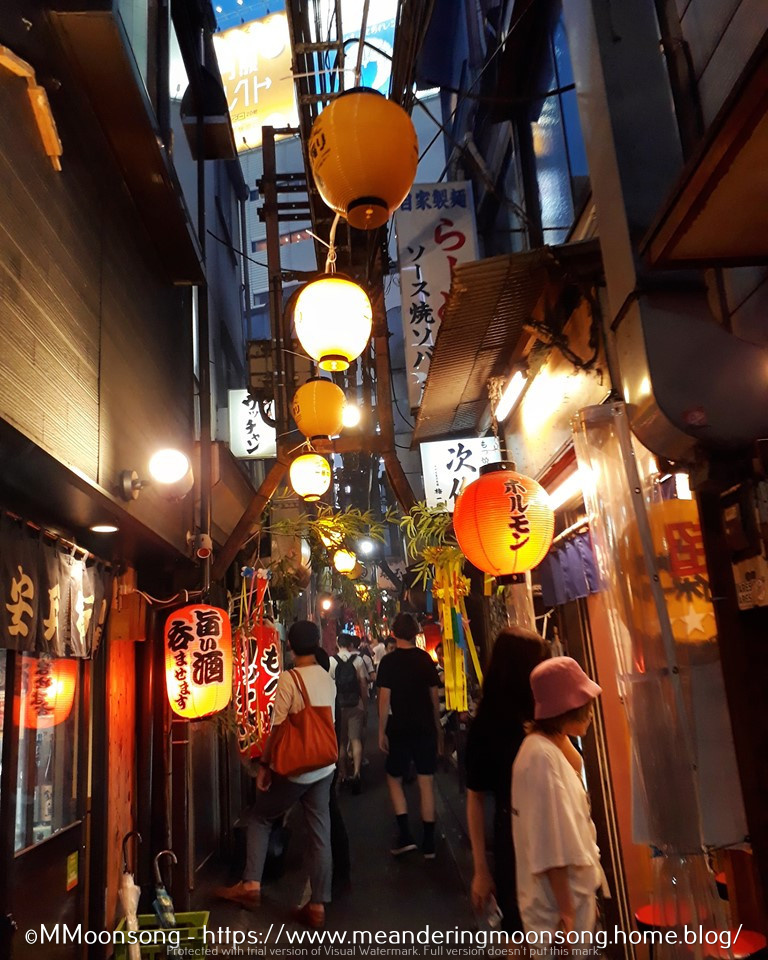
Having drunk some coffee and gained some energy after so many hours of travel, I then proceeded to the Metropolitan Plaza near Ikebukuro Station to pick up the Sim card I had booked online while still in Malta. Because yes, you definitely need google maps and google translate to make your way through Japan, a country where less than a quarter of the population knows a word of English. After a relaxing afternoon walking around the beautifully green Shinjuku Gyoen Park, I caught the tube to Omoide Yokocho, also known as ‘Memory Lane’ – a maze of narrow alleys peppered with red lanterns and tiny open restaurants and stalls offering traditional Japanese street-food at worthwhile prices. Previously home to a post-war black market, this is where today tired locals head after a long day at work to unwind with a glass of beer and some yakitori chicken. Golden Gai, a collection of more than 200 mismatched rundown bars lining the alleyways and corners of Shinjuku, is another such spot where one can eat and drink very cheaply surrounded by locals and the occasional celebrity. The nightlife in Shinjuku is loud and friendly. One can also meander to Kabukicho, the red light district a stone’s throw away.

Memory Lane – Shinjuku

Shibuya

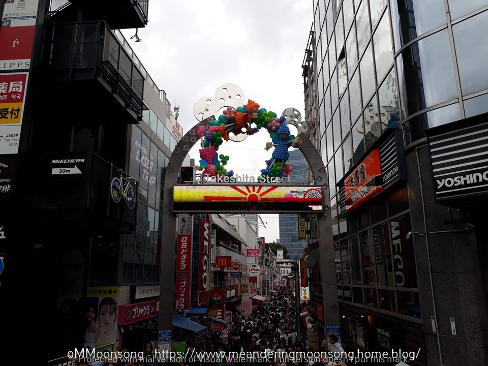
The second day of my stay in Tokyo saw me in Shibuya gaping at the very famous Shibuya Crossing, rumored to be the busiest pedestrian intersection in the world, where approximately 2,500 pedestrians cross at one time coming from all directions at once. Momentarily lost in a sea of metropolitan bustle, I made my way to the well-known Takeshita street, landmark of quirky fashion and unique boutiques. Situated in the Harajuku District, it is here that Gothic Lolitas, dressed in their cute frills, lace, Victorian hats and webbed parasols, parade their particular fashion subculture, congregating on Harajuku bridge, eating crepes at one of the many candy shops or shopping for colorful wigs in appropriate costume stores, of which there are many.

Takeshita Street – Shibuya
A Lolita Store in Takeshita Street

Following all the excitement and rush of humanity prevalent in this area, I made my way to the quieter Meiji Jingu Shrine. A green oasis of majestic trees flanked by huge torii gates, this shrine and the adjacent Yoyogi Park offer a surprisingly large forested area within a densely populated city. The shrine, completed in 1920, is dedicated to Emperor Meiji and Empress Shoken and is perfect for a relaxing stroll.

Meiji Jingu Shrine – Shibuya
Meiji Jingu Shrine

Deciding to spend a kawaii morning, our first stop in Shinjuku after picking up our tickets was the amazing Alice on Wednesday – an Alice in Wonderland themed shop tucked into a side-street but which is quiet large, spreading its magical wares on three floors of girly jewellery in the shape of roses, teacups and top-hats, rabbit mugs, ‘eat me’ and ‘drink me’ cookies, sweets and playing cards, and even handbags in the shape of clocks (I couldn’t help but buying one of these). My boyfriend looked like an elephant in a tea-house, but I appreciate the fact that he waited while I browsed every item minutely, surrounded by other shrieking girls, teens, older women and even toddlers. If you are an Alice in Wonderland aficionado, you can read more about it here.

Asakusa

Craving the vibe of an older, historic Tokyo? Asakusa is the perfect place to imbibe and literally soak in traditional crafts shops, street food stalls, not to mention the classical bath houses or onsen, the famous Japanese hot springs where the natural water contains therapeutic properties and mineral salts said to alleviate a number of health issues. My day began with a trip to a kimono-parlor, where I was outfitted with a yukata – a light cotton summer kimono, the traditional Japanese garment. Having booked this service in advance, I was also served by a hairdresser, who teased my hair into an appropriate style, complete with colorful Japanese hairpins and flowers.

Kimono Store – Asakusa

Declining the extra services of a professional photographer (such parlors always offer this at an augmented price, as well as the use of traditional rickshaws pulled by locals), I made my way on wooden clogs towards Senso-ji Temple nearby. Tourists and even locals were very happy to take photos of me posing in front of this Buddhist temple built in the 7th century. In fact, many of them asked to take photos with me using their own phones as a keepsake, as though I was a tourist attraction myself! The yukata is a surprisingly cool garment considering its floor-length and with full long sleeves, however walking around the enormous temple soon made me hungry and propelled me towards one of the many small ramen-shops lining the street. Ramen soup, made of chicken or pork stock and combined with a variety of ingredients such as whole eggs, seaweed, kombu (kelp), shiitake mushrooms, onions and meat amongst others, is the perfect filling Japanese meal. Tasty and healthy!

Traditional Ramen Soup

Akihabara

Also called the ‘Electric Town’ and situated in Chiyoda ward, is another treasure-trove for all anime, manga, comics and video game lovers, better known as otaku. Home to Mandarake, the largest second-hand comics retailer in the world, this district offers not only shopping centres and computer goods, but also a huge number of what are known as ‘Maid Cafes’, a type of cosplay restaurant where the waitresses are dressed up as kawaii frilly servants redolent of Victorian French maids, as seen through the lens of the prevalent anime aesthetic. A number of rituals and additional food services are available at different maid cafes, which are in no way related to the sex trade, but are merely an innocent way for the itinerant tourist or fan to feel part of a cosplay experience. A number of other anime themed cafes in Akihabara include Gundam Café and the Final Fantasy Erzora café. Gaming arcades and centres are another attraction found in Akihabara. Here one can meet with other gamers, enter contests and even sample the latest gaming technology. Most notable of these arcades are the Sega building and Taito Hey, which specializes in vintage and retro game arcade machines.

Mandarake Store – Akihabara

Ginza

In love with international brands and limited-edition accessories? Then Ginza, full of upmarket boutiques, ritzy cocktail bars and sushi venues, redolent with luxury goods and high-end retailers, is surely the place for you. It is here that French companies such as Chanel, Dior and Louis Vuitton, Italian companies like Gucci, and American bastions of fashion such as Carolina Herrera, have their flagship stores. A number of art-galleries and theatres also predominate, most notably kabuki theatres offering a selection of classical Japanese dance-dramas. Kabuki theatre is known for its historical roots, elaborate masks and make-up and cultural folk tradition dating back to the Edo period (1603 – 1868).

Although I mentioned these five districts in particular, all of Tokyo’s wards offer their own particular flavor. One could go to Ueno prefecture, known for its ornate shrines. Spend the afternoon roaming Tsukiji fish market in Chuo city, eating street-food and perusing stalls at their heart’s content. Another sightseeing gem is Tokyo Imperial Palace, found at the heart of Chiyoda ward. How many days does one need in Tokyo? I don’t think I can really answer this question. Five days were definitely not enough to explore it all. I will be back!

Me and him at Senso-ji Temple – Asakusa
Advertisement

A Hidden Paradise – Exploring the Zingaro Nature Reserve

No tarmacked roads in sight, no cars, no concrete houses, no telephone cables, no traffic noise-pollution. Just pure unmitigated peace, small pristine beaches amidst rugged countryside, spectacular sea-views, lush hiking trails, florid plants growing in the shade of rich trees while seagulls circle over picturesque grottos and hedgehogs peep at you from beneath a canopy of leaves. Heaven? Not at all, I found all this and more at the Zingaro Nature Reserve in Sicily.

Tired of the humdrum of everyday life, some months ago I decided to take myself off to Sicily for a long weekend. It wasn’t the first time I had visited the island, and this time I wasn’t interested in exploring cities, going shopping or even admiring historical architecture and art. I just wanted to take a deep breath, stay still and relax for a while. Which is why Zingaro Nature Reserve, located just an hour west of Palermo, near the small town of Scopello, was the perfect place to go. This little paradise opens daily from 7am to 7pm and sports two different entrances, the most popular one being accessible from the coast road that ends just beyond Scopello, while the other less busy entrance is close to San Vito La Capo in the north. We were staying in the village of Trappeto, so the Scopello entrance was the closest one for us. Also, this entrance has a free car park and an information centre, where the very helpful staff gave us a map of the Reserve and its possible trails.

The leaflet informed us that Zingaro Nature Reserve was actually Sicily’s oldest and first protected area, and that it was established as a reserve in 1981. This spectacular location stretches for 7km along the unspoilt coastline of the Bay of Castellammare and its mountain range, and offers hikers and explorers three main trails. The ‘easier’ one is the Coastal trail, which winds around the coast and bays and takes approximately 4-6 hours to traverse from one side of the Reserve to the other. The second one, which is described as ‘Moderate’, is the Middle Coast Trail, which is an 8.5 km winding walk in the middle of the landscape and rural scenery, with the coast on one side and the mountains on the other. The third option is the Tall and Middle Coast Trail, which is the longest route and goes straight through the Bosco of Sardinia, famous for its pine trees. Of course, stating a specific time for how long one will actually take to walk through each trail is very subjective, since this depends on the hardiness of the hikers, the weather conditions, and the terrain. It will definitely take longer if you opt to stop for a picnic. I recommend starting early if you plan on spending the whole day exploring the place, since you definitely don’t want to find yourself crashing through the undergrowth in darkness. There are no electrical external sources of light within the Reserve.

One enters Zingaro proper through a short tunnel. As soon as one emerges from it, the whole enchanting vista of mountains, woodland and coast opens up in a sudden magical light-burst. The main trail splits into a few others but they are very well marked. We chose the Coastal trail, which is a bit hilly and sports some ups and downs, but which is a very good choice particularly in summer. This is because of the 7 different natural beaches found alongside it, not to mention the picturesque craggy coastline. Perfect if you are an avid photographer, or if you just want a dip in the cool water. After a few minutes walking along this trail, we came across the tiny Museum of Marine Activities. I must confess, at this point the thing I found most interesting here was the bathroom, and boy was I fortunate in stopping there! A serious word of advice, toilets at the Reserve are very few and far between since they are only found at the four small museums interspersing the various trails. So, make the most of them!

Cala Mazzo di Sciacca

After around 20 to 30 minutes of walking in the scorching sun of June, we finally spied the first natural cove or cala. This was the Cala Mazzo di Sciacca, a small virgin-white sandy beach with not a soul in sight. The water sparkled as I gazed at it longingly, because yes, obviously, I had forgotten my swimsuit in the car. The temptation to just wade into the azure water au naturel was overwhelming, but thankfully I didn’t give in to it. No sooner had we taken our photos and decided to reluctantly continue to follow the path, than two whole families of tourists descended on us replete with towels, plastic toys and lunchboxes. Many people in fact visit Zingaro Nature Reserve for its unique beaches, so less crowded and so much cleaner than more mainstream swimming locations. Entrance to the Reserve only costs €5 for adults, which is very worth it considering the amazing experience.

Cala Capreria

We continued on towards the next bay on the map, the Cala Capreria. At this point the heat was quite intense, and I was very sorry that we hadn’t thought to bring some water with us. Another note of warning, don’t be as careless as I was. Take drink and food with you because there are no stops and nowhere to buy anything. It is pure unmitigated beautiful wilderness. I did at least think of wearing sturdy tennis shoes and not flip flops or sandals, which would have been terribly uncomfortable on the craggy terrain.

The Reserve sports seven beaches in all; one of which is only accessible by boat. In fact, for those who are not interested in hiking but just want to glory in the popular calas, there are a number of cruises available whereby one can buy a ticket and visit all these beaches and more by boat. Ferries are available from San Vito La Capo and other coastal resorts. Although one need not be a jock or professional athlete to brave walking around the Reserve, it is definitely not for the physically unfit or for those with special physical needs, therefore taking a cruise might be another way of experiencing another side to the location. The waters around the reserve are also excellent for scuba diving. The Zingaro Reserve is wholly pedestrian, meaning that one can only explore it on foot and that no cars may enter this safe space.

Moving on, we arrived at the Punta Leone, which is a natural rock formation supposedly in the shape of a lion. To be honest, I didn’t realise this until it was pointed out to me by a very friendly and helpful ranger. He also shared some of his water with us, for which at this point, I was profoundly grateful – thank you again Vincenzo!!

Image Source: www.eventitrapani.it

Vincenzo also told us that had we started walking from the northern entrance, the once closest to San Vito la Capo, instead of the southern one, the trail we would have traversed would have been less hilly and problematic. Also the four beaches closest to that entrance are closer to each other too, making the trail easier to navigate. He was very boastful of ‘his’ Reserve, talking non-stop about the 650 different species of plants, shrubs, palms and colourful flowers which dot the landscape, as well as mentioning  the local bird population which usually acts as a magnet to those interested in ornithology. These visit the Reserve to study the eagles, falcons, peregrines, partridges, kestrels, owls and seabirds found here. The grottoes and cavers along the coastline are also inhabited by eight different species of bats. Needless to be said, it is forbidden to take rifles or any kind of fishing equipment in the Reserve.

I must admit that at this point I was totally wound up as it was very hot and there was also the return journey to consider (since we had left our car at the parking lot near the southern entrance), therefore I admit that I only walked until mid-way of the coastal trail, that is, as far as the Cala della Disa. Funnily enough, even though the rangers and museum curators encountered along the track continued to tell us that such and such a location was ‘only ten minutes away’, each time the walk was markedly lengthier than that, so try not to take experienced trekkers at face value, especially if, like me, you generally prefer a cool drink and a good book on the couch to a laboriously sweat-drenching walk in the Sicilian sun. However Zingaro Nature Reserve was well-worth the effort. Seriously though, I won’t try to tackle such a track in summer again, as I’m sure the experience would be much more enjoyable in spring or autumn. Still, I will surely visit Zingaro again next time I visit Sicily, even though this time perhaps, I will traverse it from the easier and less hilly Northern side.

This article, written by yours truly, was originally published on The Sunday Times of Malta.

Snowdon – The Highest Mountain in Wales

Whenever we look up at a mountain, one of the first questions we usually ask ourselves is, ‘I wonder what it all looks like from up there?’ Yr Wyddfa, or Snowdon, is no exception. Its summit offers without a doubt, the grandest view in Wales – not a surprise, since at 1.085 meters (3.560 ft) high, Snowdon is the highest mountain in all of not only Wales, but also England. And this is why I absolutely had to visit this monumental site while I was in Wales a while ago.

I must admit – I am not a very sports-minded person. I don’t like walking much, and I have never tried mountain-climbing, which is why I have frequently thought that reaching the summit of a mountain for me would be practically impossible. Fortunately however, I was totally wrong. At least with regards to Snowdon. This is because the summit of Snowdon, also known as the ‘roof of Wales’, can be reached not only on foot, but also by railway. Be warned however, tickets are on a first-come, first-served basis, so the easiest thing to do if you want to journey up the mountain by train, is to visit the official website and book your seats beforehand, instead of trying your luck at the ticket booth. I have spoken to a number of people who made the journey to Snowdon, which is found within the Snowdonia National Park in the county of Gwynedd, and who told me that once they arrived at the ticket booth, they had to leave empty handed, as the train-carriages were all fully booked for that day already. So, it’s much better to plan ahead and make hay while the sun shines.

In front of the small train station

My journey to Snowdon was a memorable one. I had done my homework so I knew that the railway is usually closed from October to March, since the mountain can be quite dangerous during the bad winter-time weather, which is why I visited the park in September. I had also found a number of YouTube videos of the train journey, uploaded by errant tourists, therefore I also realized that the train-carriages were not large, and that they each had limited capacity, which is why I booked my tickets online. When we arrived, we parked our rented car at the Pen-y-Pass car-park, which is directly in front of the restaurant, gift-shop and ticket booth found at the foot of the mountain. There was a very nice parker there who refused to let us pay before we had checked whether the train was actually working on that day or not, since there was a bit of a high wind and trains usually do not make the journey during bad weather (in such cases, full refunds are given). Everything was fine however, so our hope of reaching the summit on that day were fulfilled.

Our train!

The train was really cute and small and we couldn’t refrain from taking some selfies with it. We boarded and started our ride, which we knew would be 4.7 miles (7.6 km) long and take approximately two and a half hours – one hour to the summit, half an hour there, and then another hour back. I was immediately struck by the beautiful atmosphere and panorama which one can admire from the train-carriages itself. These have huge glass panels from where one can take as many photographs as one likes. The train chugged along slowly, both to give us tourists a chance to take pictures, and also because the mountain terrain is not easy to traverse. A multitude of sheep and goats looked at us pass by slowly, while we gazed in wonder at the magical panorama unfolding around us. Gone were all traces of modern civilization, as we were surrounded by nature, animals and plants. Snowdonia National Park is in fact a national nature reserve and contains a large number of rare flora and fauna.

The view from the train

As the driver told us about how Snowdon Mountain was formed out of volcanic rocks sculpted by ice during the Ice Age, we were further amazed to see a waterfall plunging majestically into a 20 metre gorge directly below us. Cameras clicked madly as the train emerged into the open, treeless countryside and we had the first glimpse of the sharp peak of Snowdon. The landscape all around us was dotted with many tiny abandoned, simple shepherd-dwellings. Just behind the ridge, we could also see the Snowdon Ranger path, as well as the youth hostel. Some intrepid young people, burdened with climbing gear, picnic baskets, and jackets, were starting to walk along the track up the mountain and we waved at them gleefully as we passed. While the journey from Llanberis (that is, the foot of the mountain) to the small station at the summit, takes an hour by train, it usually takes around 6 hours covering between 7 to 10 miles, for those who brave the journey on foot, depending of course, on the path taken. There are in fact, six main routes to the summit, ranging from ‘beginner’ to ‘expert’ mountain climbing skills. Climbing the mountain on foot is not as hard as one might think, especially in good weather conditions, however one must keep in mind that the right equipment, know-how, and resources are needed. Mountain slopes can be treacherous and slippery, and in fact a large number of people were injured and even fell and died while climbing this mountain throughout the years.

Snowdon village could be seen below us at this point. We could also see the passage of time when we looked at the old quarry near it, which showed the sedentary rock blending into slate. Very colorful and interesting. As the train continued its journey upwards, we could also see the Hill of the Falcon in the distance – so called because it is the home of a large number of rare Peregrine Falcons, as well as Llydaw Lake, which is one of Snowdonia’s deepest lakes. Half-way up the mountain we stopped in order for the train to re-fill its tanks and for the tourists to have a cup of coffee at the halfway Café. It was really getting chilly at this point, and I bemoaned my fingerless gloves and thin hood, which weren’t nearly enough to protect me from the glacial climate. Beyond the coffee shop, we could see Glaslyn Lake, with its seemingly black and silent waters. I could very well understand how this strange place could inspire people to believe in the legend of the afanc, which is a water-monster who is thought to reside in it. Another legend relating to Snowdon Mountain relates how the giant Rhitta Gawr, who wore a cloak made out of men’s beards, was killed by King Arthur after trying to take his beard, and is buried at the top of Snowdon.

Glaslyn Lake

As we approached the summit, it was so cold that the drops of mist were like rain against the window panes. Everything was obscured as we entered a cloud of condensation, and as the doors opened to admit us to the coffee shop station at the top, we were told to be careful and not miss the train which would go back in 30 minutes, as there would be no more journeys for that day. Frozen stiff and knowing that the best was yet to come, we started walking towards the peak which, we were told, was only a few steep steps ahead. Wet, slippery, uneven steps, which one had to climb in the blinding mist and freezing wind. I admit at this point I was quite scared, but I consoled myself by thinking about the amazing view awaiting me. Snowdon is well known to offer one of the most extensive views of the British Isles – since in good weather Ireland, Scotland, England and the Isle of Man are all visible, as well as 24 counties, 29 lakes, and 17 islands.

Reaching the Summit
The height marker at the peak of the mountain

Unfortunately for me, this was not one of those days. Snowdon is close to the sea which means that the weather changes frequently. The only thing I saw from the summit was a wall of mist. I took a photograph with the height marker at the peak, and we went back for the return one-hour ride. Although I did not get to see the famous panorama I was aiming for, I still feel like it was a memorable experience because the journey up the mountain was an adventure in itself. Still – Snowdon remains an unreachable mystery, so perhaps someday I will go back, and who knows, maybe that day I will try to brave one of its rock-climbing routes on foot.

This article was originally published on The Sunday Times of Malta

Chasing Nessie – Cruising Loch Ness

No holiday to Scotland is complete without a visit to Loch Ness. Booking a boat trip on the Loch was, in fact, the first thing we did right after purchasing our plane tickets.

Being a lake and not a sea, Loch Ness is not susceptible to particularly rough water currents affected by wind, tides or weather conditions. Most such guided cruises operate throughout the year. I still went prepared for a chilly voyage however, bundled up in a good jacket, mufflers and gloves, since I was visiting Scotland during the month of September and could certainly imagine how nippy the air over such an extensive body of freshwater as the Loch, could be.

Cruising the Lock – So windy!!

My aim was definitely, first and foremost, to enjoy the experience without buying any souvenirs or geegaws. However, I admit that I totally succumbed to the urge when, after we had parked near Clansman Dock, where our boat was to cast off, we visited a large nearby hotel to use the facilities. The foyer of the hotel was tantalizingly arrayed in paraphernalia relating to the Loch and its legendary monster and I couldn’t help but buy some presents for my family as well as a small Nessie soft toy for myself.

After that, we decided we were definitely not going anywhere near Drumnadrochit, which is a small village at the foot of Glen Urquhart directly next to the dock and which thrives on tourists visiting its extensive Loch Ness Centre as well as the nearby Nessieland, which is a small theme park for children.

As I queued in front of our boat waiting to board with some other 20 passengers, the panoramic vista of the Loch in front of me was a pleasure to behold. I had, in fact, already actually experienced quite a stretch of the Loch, seeing that we had driven down the Scottish Highlands from the city of Inverness.

What many don’t know is that the legend of the monster of Loch Ness is indeed much older than these well-known sightings

However, peering at the large freshwater lake from a car, and actually floating on it on a small boat are two entirely different things. The small craft itself was impeccably furnished with a mini-bar and other indoor luxuries, including a number of panels sporting marine sonar units able to recognize objects underwater through sound-reflecting wave pulses, which could reveal any target. These, our guide told us, were usually used for underwater surveillance, but in this case they were there to show up Nessie, should he or she appear.

Magical Loch Ness!

Needless be said though, as the boat left the pier no one remained inside. Everyone went out on deck to admire the blue water of the lake, mirroring the perfect azure sky and unveiling a vista of virgin woods, mysterious lighthouses, lone farmsteads and tiny villages which dotted the banks of the freshwater lake, most notably the picturesque villages of Foyers and Dores.

As we looked on in amazement, we could see a number of people walking and hiking along the Loch, while small fishing boats and other cruising vessels bobbed on its calm surface.

Our guide informed us that Loch Ness was over 23 miles long, a mile wide and 700 feet at its deepest, making it the largest lake in Scotland by volume. It is, however, the second largest Loch by surface area, after Loch Lomond.

Loch Ness contains more fresh water than all the lakes of England and Wales combined and runs from Loch Dochfour to Fort Augustus. The waters of the loch flow along the River Ness through Inverness and into the North Sea. As I imbibed all this information, I looked around at the towering dome-shaped peak of Mealfurvonie, the loch’s highest mountain, which flanks the lake in majestic beauty, together with a multitude of breathtaking rolling green hills.

Cameras clicked madly as the guide proceeded to recount some of the many legends pertaining to Loch Ness. These of course, mostly surround the legendary sightings of Nessie, a large and ancient aquatic prehistoric creature which ostensibly inhabits the lake. The so-called ‘monster’ with its reputedly arched neck and benign expression, first captured popular interest in 1933, when a local couple spotted it gambolling in the water.

A few months later, a British surgeon came forward with a shadowy photograph which appeared to show an enormous sea-serpent-like creature swimming in the lake. This photograph was for decades believed by many to be ‘proof’ of Nessie’s existence and it was only in 1994 that, after a confession on his deathbed, one of the men involved revealed the plot to perpetrate this hoax.

What many don’t know is that the legend of the monster of Loch Ness is indeed much older than these well-known sightings as the creature was actually first mentioned in a 7th century biography of Saint Columba, an Irish missionary who spread the Christian faith in Scotland during the 6th century and who is said to have prevented Nessie from killing one of his monks through the power of prayer.

All tales of folklore flew directly out of my mind as our boat suddenly approached the beautifully preserved stunning medieval ruins of Urquhart Castle. Built on the banks of Loch Ness in the 13th century, the castle definitely dominates the landscape for miles around.

Urquhart Castle Ruins

The visit to this fortification was the climax of the tour. The castle is one of the largest found in the Scottish Highlands and is surrounded by a ditch and a drawbridge. Standing on a rocky promontory, I couldn’t help but feel as though I was entering a fairytale as I swiftly passed through the well-planned visitors’ centre to emerge into the fresh breeze coming from the lake. A full-sized working replica of a siege engine immediately caught my attention, after which I proceeded to cross the wooden drawbridge and start exploring the gatehouse and the great hall.

Climbing the five-storey Grant Tower was a treat and it was very interesting to read the many plaques provided with relevant historical information about the castle, its strategic location and the role it played during its 500 years as a medieval fortress.

As I nursed a piping hot cup of coffee on the journey back along the Loch, I thought about the sonar equipment and very much doubted that a prehistoric animal could inhabit the lake without it being spotted in this day and age. Yet, I admit, as I looked down at the deep unfathomable water surrounding me, I still couldn’t help but try to once again to spot a shadowy presence or strange ripple marring the calm surface.

This article was originally published on The Sunday Times of Malta.

The Punkva Caves and the Macocha Abyss

The subterranean Punkva River, being almost 30 kilometers in length, is the longest underground river in the Czech Republic. It is thanks to the erosion, fluctuation and twisting flows of its many tributaries that an extensive system of underground passages, domes and abysses was formed underneath what is known as the Moravian Karst, a protected nature reserve on the eastern part of the Czech Republic.

This beautiful region is home to a number of unique geological features, not least of which are a number of cave systems underlying the lush green woodlands and forests. The most famous of these cave networks are the Punkva Caves located to the north of the city of Brno, which showcase one of the natural wonders of the Czech Republic – the Macocha Gorge.

Fortunately, we had researched our destination well before actually visiting the caves and so realized early on that they could only be accessed through a guided tour. Since tours of the caves only take place at allocated times, not to mention the fact that the place is a famous tourist attraction, it is important for anyone interested in visiting to book the tour beforehand.

We bought our tickets online, yet still had to visit the Visitor’s Center to exchange our e-mail with the actual tickets. While there, we were also told that if we wanted to take photographs in the caves, we had to purchase a colored sticker for a small fee and attach it to our clothes. This may seem strange, but it is common procedure in certain countries.

Armed with tickets, stickers, cameras and expectations, we boarded the small tram from the Visitor’s Center to the entrance of the Punkva Caves. One can, of course, opt to walk the two-kilometer woodland trail instead of using the tram. Once we arrived in front of the entrance, I abruptly realized that it would be much colder underground, and that the light clothes I was wearing, suitable for a stroll in the sun, were definitely not enough for the freezing caves.

There was only the official merchandise store nearby, so I hurried over and bought a bright red ‘Punkva Caves’ sweater for the occasion. It did keep me warm during the one-hour tour and was also a very nice souvenir. At least I had the good sense to wear comfortable sneakers.

Our group was made of around 30 people. I was glad to see that there were even small children and senior citizens – a clear indication that there were no dangerous, unsecured sheer drops or rough terrain to climb ahead. After all, one does not need to be a miner to explore the Great Underground! The caves are, in fact, very safe for visitors, being equipped with plenty of lighting and having level floors and stairs. Unfortunately, it was at this point that we realised that the tour was in Czech and that there were no tours in English available. However, I had previously found and downloaded a free mobile application with a tour book of the caves on my mobile phone and I found that very helpful.

The tour itself is actually divided in two parts. The first part is on foot, while the second consists of a very atmospheric boat-ride on the subterranean Punkva River.

Mirror Lake

As we entered the caves, a four-metre-long stalactite welcomed us in the Front Dome, a large, hall-like space filled with myriad stalactites and stalagmites. Walking on, I was literally mesmerised as I encountered the Mirror Lake, whose waters are so clear as to leave one in total awe. Two worlds seemed to meet, divided by the water’s surface, as the crystalline stalactites met their counterpart through the underground lake’s reflection.

Steep steps took us up a 10-metre shaft-like tunnel leading to what is known as the Dome of Destruction, in reference to a cave collapse which had occurred sometime after the dome’s excavation. Following a corridor of naturally shaped water-columns, we were finally behind two impressive rock formations known as ‘The Angel’ and ‘The Curtain’. Looking up at the majestic play of water on rock, one cannot help but feel a sense of greatness at the power and wonder of nature.

The ‘Angel’ and the ‘Curtain’ formations

Having covered almost 810 meters of the 1,250-meter tour, which is the longest underground trail open to the public in the Czech Republic – the best was yet to come. We proceeded in single file through a narrow tunnel passage opening up to the inspiring Macocha Gorge, also known as the Macocha Abyss.

This 138.7-metre deep sinkhole is the deepest of its kind in central Europe and can be viewed from the bottom up from the Punkva Caves. One can also take a cable car from the surface to the top to admire some unforgettable views.

The Macocha Gorge

Being in a cave while looking upwards at the sun through a gorge and seeing the green trees of the forest sparkle and being reflected in the two small lakes at the bottom of the abyss is truly a magical experience. Once our eyes adjusted to going from almost total darkness to blinding light in only a few minutes, taking selfies and almost full blown-out photoshoots was inescapable.

The lakes at the bottom of the Abyss

At this point, our tour guide bid us goodbye as she led us to the second part of the tour. A small underground dock dotted with some tiny boats awaited us. Our group split up further, since the minute boats could only accommodate eight people.

Our second tour guide, an old, crusty man steering the wooden boat with a paddle, again spoke only Czech. In halting heavily accented English, he warned us sternly that photographs were not permitted on the boat, as this could be dangerous since we would be passing through very narrow channels, and any excessive movement could cause the boat to capsize. He also warned tall people to keep their heads and hands down, since some of the tunnels were quite low and they could easily hit their head on a stalactite.

I honestly thought he was joking, but he was dead serious and with good reason. The boat buckled alarmingly as we cast off and slowly meandered through the winding river.

As we left the small dock, the walls started to close in, together with the darkness and the cold. At that point, I was grateful I did not suffer from claustrophobia. Later I learned that the water of the river has a depth of approximately 50 metres, but at the time, feeling the weight of the earth on my head, twisting this way and that trying not to get hit in the head by a stalactite, the cold dark surface of the river seemed to hide something more sinister. The old man steering the boat reminded me of Charon ferrying the souls of the newly deceased across the River Styx, surrounded by seemingly fragile dripstones and colourful rock formations hanging from the cave’s ceiling.

Floating between the darkness of the caves and the darkness of the waters below through a succession of narrow tunnels with low ceilings and small fairytale pools felt like a breathtaking dream. In the end however, we had to wake up, as the boat floated up the river to the Punkva Spring above ground. This is where the tour ended.

Taking back the tram to the Visitor’s Center once more, we were pleased to note that the smaller Katerinska Caves were only a 10-minute walk away, so we were overjoyed to visit them as well, before stopping at one of the charming restaurants nearby for lunch. An anti-climax, but a very needful one after such a memorable adventure.

This article was originally published on The Sunday Times of Malta

The Largest Castle in Sicily!

Castles – be they medieval, Norman, military fortresses, well-kept luxurious palaces, or ruined keeps – I’m in love with them all! No matter which country I travel to, I am never tired of exploring and discovering these architectural recipients of historical happenings! By the way, should you like to read some of my articles on a number of castles I’ve visited, please don’t hesitate to visit http://castles.today/ which is a Polish website I contribute to regularly (take a look at my uptake on Welsh, Scottish, Irish and Maltese historical castles amongst others).

Obviously, taking my interest in castles into account, I couldn’t NOT visit Sicily, one of my favorite vacation-spots, without also exploring a number of castles and palaces there.

There are many beautiful Castles in Sicily, such as the Castle of Venere in Erice (been there twice) or the Castle of Castelmola (blogposts on these places will be forthcoming soon-ish) however this time round, during my last trip to Sicily I visited a Castle which is less well known, though no less amazing.

This particular historical gem, is in fact the largest castle to be found on this Mediterranean island, that is, the Castle and Citadel of Milazzo. Found in the small town of Milazzo, in the southern part of Sicily, this romantic architectural treasure is resplendently obvious as it is situated on a hill, majestically lording it over the nearby countryside and port.

When we arrived, the local old guy selling tickets immediately befriended us and launched into the history of the castle, boasting about it as though it was his own home. He told us how the site itself had first been fortified in the Neolithic era, then manned by the Greeks, and later conquered and enlarged by the Normans, the Romans, and later the Aragonese (Spanish). Actually, it’s me the guy latched on to, since my boyfriend does not understand Italian, however I obviously couldn’t stand there bantering all day, so we finally managed to excused ourselves and went into the castle itself.

And it was HUGE. First of all, let me be clear, when I say ‘castle’, I mean the whole citadel of course, that is the castle, grounds, and surrounding buildings. The grounds are quite big, though overgrown with local plants and wild flowers, which was part of their charm. There was an old but well kept church sporting some crumbling frescoes, as well as a number of buildings hosting a museum, a children’s area, and a number of rooms dedicated to the Second World War.

The real wonder of the site however were the medieval ramparts, where one could delightfully gaze at the spectacular panorama of town, port, sea, and countryside simultaneously. 360 degrees of paradise!

Yes please!

If you visit Sicily in the near future, make sure to save some hours for Milazzo Castle. You won’t regret it!

🙂

The Streets of Ghent and Antwerp

Waking up in Ghent is truly an experience. My room at the B&B I was staying in, was only a couple of floors up, however the night before, I had purposefully left the curtains of the two large windows open, so as to be able to see the sun rising over the medieval cobbled streets. Needless be said, I took the opportunity to take a couple of photos before going back to bed too.

The romantic streets were silent and deserted so early in the morning. As I watched the alley across our room, an early-bird (possibly a baker judging from his overalls) locked his house behind him, got on his bike and pedaled off to work. Cars, of course, are not permitted within the small historic streets of Ghent. Only bikes. And boats of course. Did I mention the fact that Ghent is full of canals? Like Bruges, some actually call it the Venice of Northern Europe!

After another short nap, I heard the landlady tapping at my bedroom door, signalling that she had left the breakfast tray outside. As I opened the door, the scent of newly-baked bread almost made me swoon (she later told me that she went expressly for it at the baker’s at around 5.30am each day – blessed lady!). There were pots of jam, some delicatessen items, hot milk, eggs (we could prepare them on our small stove in the kitchenette as we preferred), etc… I must say it was one of the best breakfasts I ever ate. Obviously compounded by the peaceful medieval view from the breakfast table! While eating breakfast, I planned my day, which I was going to spend in Antwerp.

Antwerp, a Flemish medieval city in Belgium, is actually a port city, and its port is one of the largest in the world, ranking second in Europe. Its origins date back even before the 14th century. It has a large number of historical landmarks, not to mention cultural ones, since the artworks created by its famous 17th century school of painting (not to mention other arts such as weaving), were sought after throughout the world. Unfortunately, I was fully aware that I would be unable to visit as many of the places I was interested in, since I only had one day to spend in Antwerp, however I fully intended to try my very best.

After having taken the train from Ghent to Antwerp, while leaving the train station, I was immediately enchanted by the beautiful flowering streets of this sweet city. Colorful flowers and plants flourishing in the warm spring sun, decorated every corner, as people from every imaginable country, ethnicity and nationality thronged the pavements. Shops sporting popular brands abounded, however to be honest I was more drawn to the tall medieval gothic-style buildings which majestically reared their sculptured facades right next to them! It seemed like there was so much to see! Everywhere I looked, the past sat right next to the present, and the mad cacophony of everyday life vied with the dreamy awe galloping through my senses.


Suddenly, incredibly, I heard a burst of classical music. It was a grand piano! Yes, right there in the middle of the street! A street-artist had somehow transported his enormous polished piano amidst all the flowers, gothic palaces and grand stores, and was playing a sonata as though his heart would break. Tourists, locals, and passers-by thronged around him clicking away madly at their cameras and mobile phones. Talk about live street-art!

After the quite deserted streets of Ghent in the early morning, the bustling streets of Antwerp served as a real contrast. The multitude of shops, cafes, eateries, and museums to see in this city were overwhelming, yet there was also a strange atmosphere of calm – inviting you to just ‘browse and chill’… and boy did I love that!

To be honest, I do not know which I loved most – the street-life of Ghent or Antwerp. Both are uniquely beautiful and enriching in different ways.

Using Land Transport

Whenever I’m conversing with someone about travel and holidays, it’s surprising how many people seem to find land transport to be one of the most difficult issues to navigate through (pun intended).

Travel, in my opinion, is all about adventure and exploration. I’m not one to spend hundreds of euros to travel to a beach to relax somewhere, which I can very well do in Malta or Gozo (my home-country) anyways. Instead, I prefer to see as much of the country I’m visiting as much as I possibly can.

So, when people ask me how I managed to see so many different attractions and places in such a short space of time, it’s mainly because most of them seem to have difficulty with sightseeing when the locations they want to reach are not conveniently placed in a capital city, or in a major urban area. Well, guess what? Aside from taxis (which are too expensive and inconvenient most of the time), there are actually many other easy and economical ways of travelling on land when you are in a foreign country. All it takes to be aware of them is some online research – and for this, I’m eternally grateful to the founders of google.com, Larry Paige and Sergey Brin.

Here are some ideas to help you out with regards to land travel when abroad:

The Tube/Underground/Metro

Granted, this mode of transport is not to be found everywhere, however the network is much vaster than one might believe. Although the London Underground is the most well-known and the oldest system of its kind, there’s actually a vast list of countries which make use of it. These include Algeria, Austria, China, Germany, Belgium, Russia, Japan, Italy, USA, Switzerland, Spain, and many others. The underground is usually my preferred mode of transport to and from the airport, since it’s not only economical, but also very convenient as most airports sport an underground station directly next to, if not beneath them.

Image source: BusinessInsider

Train Stations

The first recorded train station started to be active in 1803. Nowadays, efficiency and easy access to tickets have soared, in that not only can you purchase tickets from automated machines within stations themselves, but also online, which can be done days, if not weeks in advance, foregoing long queues. Railway tracks pass through mountains and valleys, operating cross-border through different countries and states. Most airports are found within at least one or two railway routes, as are a large number of remote countryside towns and even villages, aiding one in travelling across the length and breadth of most countries around the world in a relatively easy manner.

Image source: Londontoolkit

Private Coach

This is a service provided by a number of companies worldwide. Coaches are usually available from a number of focal points, such as airports or key points within the city centre, or even in front of specific hotels. All the traveler has to do is book their passage online at the time and place desired, and they’ll be automatically pooled in with a number of other passengers. Coach routes can vary, ranging from one-hour to twelve-hour journeys or more, and they’re usually furnished with bathrooms, luggage compartments, nightlights, and even beverage-machines. Most coach services are advertised in airport websites themselves, so that’s a good place to start choosing one.

ZPY_300_Zarb_Coaches_IVECO_Eurorider_C33_-_Hispano_Divo._Malta
Image source: Wikimedia

Public Buses

Although these operate mostly in and around cities, towns and suburbs, it’s still worth checking out the relevant timetables before making plans for sightseeing routes, in order to already have the times and distance between different attractions already in mind when you start out. Also make a note on night bus routes, which may be different from the day ones. Bus tickets can usually be purchased as block tickets; instead of buying a ticket each time, you can buy a 3-day ticket or a weekly ticket, depending on how many times you think you’ll be making use of the service. This could save time as well as money.

tal-linja2
Image source: Tvm

Car Rental

If you’re travelling in a group, or even as a couple or on your own, and if, of course, there’s at least one driver in your group who doesn’t mind driving abroad, this is perfectly ideal. Nowadays, there are a large number of reliable Sat-Navs (GPS) on the market, which are much more efficient than the old map-and-directions routine. Of course, it’s always advisable to look up the locations you’re visiting beforehand, and get the lay of the land. I would also recommend using Google Earth and zoom in on street view, in order to virtually acquaint yourself with the surroundings you’re about to travel through. Be especially careful if you’re going to visit a country where people drive on the other side of the road, as this may take some getting used to.

123

Image source: Gozoandmalta